


Capturing Nature’s Pulse
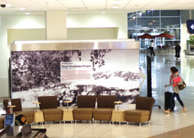
An airport is one of the last places where you expect to connect with nature. But that’s how it goes in California’s Silicon Valley. At the Mineta San José International Airport, real-time images of a wilderness area less than 10 miles away are wirelessly transmitted to a series of 42-inch LCD monitors. Nighttime displays might feature a mountain ridge glowing under moonlight, deer drinking at a pond or bobcats on the prowl.It’s all part of the Wired Wilderness Project, which is bringing live images from the Blue Oak Ranch Reserve, a field station in the foothills above San Jose, to passengers. Personal interaction is key for lead artists Freya Bardell and Brian Howe, known together as Greenmeme. “The idea is to document the landscape, these viewsheds, these beautiful compositions of nature” over time,” says Bardell, standing in the airport baggage terminal, where three million passengers pass through each year.
The Silicon Valley maintains a mild climate and uneventful seasons. But in this lightly forested woodland, goldenrod grasses carpet the hills during the summer and fall, wildflowers blossom in the spring and the Diablo range near Mount Hamilton receives an annual dusting of snow.

And this project isn’t just eye candy. Working with scientists and programmers, Bardell and Howe are visually documenting climate change impacts on a micro level. They then present these changes to the public through time-lapse photography
“The project isn’t really about the raw statistics of climate change,” such as carbon dioxide emissions, says Bardell. “We’re more about capturing nature’s pulse and making that pulse accessible to the public.”San Jose’s average temperature has been on a slight upward trajectory, according to Cal-Adapt.org, a website by the California Energy Commission. In the last three decades of this century projections estimate a rise between 3.5 and 5.8 degrees Fahrenheit compared to average temperatures between 1960 and 1980. That could mean longer heat waves and more erratic weather events. The artists are focusing on bioindicators, or biological symptoms pointing to problems within the ecosystem—similar to a canary in a coalmine.The Blue Oak Ranch Reserve, which has supported 80 research projects, is a logical starting place. “There will be a record of the Coulter pine shifting up Mount Hamilton,” Howe says. “You’ll see it moving, and migrating up the slope as temperatures get warmer.”
With cameras snapping high-resolution images 24 hours a day, every three minutes, even incremental changes at the reserve are being recorded and archived. But to capture more dramatic shifts in the nearly 3,300-acre landscape, it could take decades for the artists to deliver their deeper, underlying message.
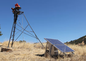
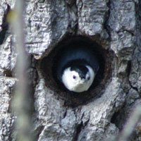
“Climate change is a very volatile subject,” says Howe. “We felt the best solution for that was to stick an impartial observer up on a mountain and watch.”The exhibit uses five image feeds, but in the beginning displays will feature images from just two of the solar-powered Canon digital SLRs housed in weatherproof boxes atop tall platforms that are programmed by microcomputers.The “pond cam” is located on a platform at the edge of a watering hole for egrets, kingfishers, deer and bobcats. The “ridge cam” is perched ridgetop on a 16-foot hunter’s tripod to capture wide shots. Images from both cameras are postcard-worthy, resembling the work of renowned photographer Ansel Adams.
“It’s Ansel Adams on steroids,” says Michael Hamilton, the reserve director. “We’re slicing the movement of time into three-minute chunks that are then captured permanently in an archive that now can be compressed and presented in a way that we don’t normally see nature.”
Hamilton, an ecologist and conservation biologist, says the images could help inform scientific approaches to conservation in the future.
Since the land was endowed to the University of California reserve system five years ago, Hamilton has set up a remote monitoring system. In addition to images, this solar-powered network of towers collects and wirelessly transmits data, such as temperature, humidity, precipitation and barometric pressure.According to the reserve director, it is one of the largest systems dedicated to the distribution of sensory measurement systems across a sizeable landscape. And because the reserve is off the grid, projects need to be energy efficient. To work within these constraints, Bardell and Howe limited each set of cameras and microcomputers to 14 watts of solar power.“There’s always a need for science to be interpreted to the public,” Hamilton adds.
The City of San José has committed to funding the installation for two years, using $33,000 of airport revenues set aside for public art. But Bardell and Howe hope future artists-in-residence will keep the project going for decades. “These short-term installations provide artists the flexibility to work experimentally using continually evolving technologies,” says Mary Rubin of San Jose’s Department of Cultural Affairs.
The 2.0 version of the Wired Wilderness Project will be a website which will serve as a platform for interaction. The public will be asked to help tag the archived photos. “This will be one very interesting social experiment to see how interactive the public who use this art want [to be] with a natural area that surrounds one side of the city,” Hamilton says. “That feedback loop is very critical.”